Mandalay
Shopping Getting around Entertainment Food Interesting places

History
Mandalay, as the center of Myanmar culture, was outstanding in the past, it holds the stage now; and it will continue to be a place of pride in the future. It is situated about 600 kilometers north of Yangon on the Ayeyarwaddy river, is, with about half a Million inhabitants Myanmar's second largest city.
Mandalay is the historical old capital, a capital of Myanmar culture, Buddhist Sasana and Myanmar traditional arts and crafts, with the life span of one hundred and forty two years, a city which abounds in historical sites, cultural memorials and Buddhist edifices. Accordingly, it is the richest historical landmark next to Bagan.
Despite the wonderful sound of its name, inviting associations to an archaic fairy tale kingdom, Mandalay is neither very old nor particularly beautiful. But Mandalay was the capital of the last, independent Burmese kingdom, which in 1886 was finally conquered by British colonial forces.
The town had been founded only 29 years earlier in 1857 by King Mindon, making it the capital of an independent kingdom for less than 30 years. In 1857 Mandalay was set up in an empty area, because, according to an ancient prophecy, in that exact place a town would come into existence on occasion of the 2,400th jubilee of Buddhism.
The city was named after the Mandalay Hill, which is situated at the northeast corner of the present city. The hill has for long been a holy mount and it is believed that Lord Buddha prophesied that a great city, metropolis of Buddhism, would be founded at its foot. It was King Mindon who fulfilled the prophecy.
King Mindon decided to fulfill the prophecy and during his reign in the Kingdom of Amarapura he issued a royal order on 13 January, A.D 1857 to establish a new kingdom. The Ceremony of Ascending the Throne was celebrated in July, 1858. The royal city and the kingdom was demarcated. The whole royal city was called Lay Kyun Aung Mye (" Victorious Land over the Four Islands") and the royal palace, the Mya Nan San Kyaw ("The Royal Emerald Palace"). The kingdom was called the Kingdom of Yadanabon, along with other name Ratanapura, mean " The Bejeweled Site ". Later it was called Mandalay after the Mandalay Hill, 2.5km far to the north east of the royal palace, and today the name still exists. The name " Mandalay " is a derivative of the Pali word " Mandala ", which means " a plainsland " and also that of the Pali word " Mandare ", which means " an auspicious land ".
At that time a transfer of the capital not only meant leaving an old town and erecting a new town in a different place. As all secular buildings of that time, including the royal palaces, were built from wood, a transfer of the capital meant the complete dismantling of the houses of the old settlement, which then were loaded on carts and the backs of elephants to be reconstructed at the place chosen for the new town.
But in 1782 the town was packed up and moved about 8 kilometers to the Northeast, to the aforementioned Amaraputra. In 1823 the entire capital was dismantled again and rebuilt 8 kilometers Southwest in Ava. But in 1838 Ava was damaged by an earthquake, and was therefore in 1841 packed up again and once more transferred to Amarapura. But this was not of duration either, as only 16 years later the entire town was moved again this time 12 kilometers to the Northeast to the present Mandalay.
The rhyming couplet easy to memorize the year of building the royal city is " Okkyit-Kyaw Aye / Mandalay " or " Aung Kyaw Chan Aye / Mandalay " ( i.e, M.E 1221 ). The city's layout of the construction is the same at that of the earlier Kingdom of Amarapura, and from the bird's eye-view, it has the structure of geographical squares and rectangular shapes, with streets and roads crossing one another at right angles. There are four parts dividing the city, namely, Ashe-pyin ( East Part ), Anok-pyin (west Part), Taung-pyin (southern part) and Myauk-pyin (Northern Part), with 54 plots.
With the Ground-breaking ceremony, King Mindon laid the foundation of Mandalay on the 6th waning day of Kason, M.E 1221, (A.D 1857). The King simultaneously laid the foundations of seven edifices: the royal city with the battlemented walls, the moat surrounding it, the Maha Lawka Marazein Stupa, the higher ordination hall named the Pahtan-haw Shwe Thein, the Atumashi ( the Incomparable ) monastery, the Thudhama Zayats or public houses for preaching the Doctrine, and the library for the Buddhist scriptures.
At the time of building, the royal moat was 68.58m wide and 3.35m deep, and was fed with water from the Yadana Nadi, now called the Ye Ni Canal. In 1995 the moat was dug anew and the banks were laid neatly and firmly with rocks. There existed 20 gardens, a huge earthen wall and 57 doors palace. There existed 5 bridges spanning over the moat and 12 bridges. At present, there are four spanning bridges, namely the U-hteik Bridge to the east the Kyaw Moe Bridge to the south, the Kye Mon Bridge to the west and the Lay Thein Bridge to the north.
When King Mindon passed away, his son King Thibaw ascended the throne, and in M.E 1247, Myanmar fell under the British colony. It was the old capital ruled by two successive kings the one where the last of Myanmar's monarchs reigned.
After the British had conquered Mandalay in 1886 they turned the royal palaces of Mandalay into their military headquarters and christened the complex Fort Dufferin.
During World War II the Japanese installed a military camp in the same place, which then was bombed by the allies, until nothing was left of the ancient palace buildings.
Mandalay today is a striking phenomenon composed of modern and classic images with the ancient cultural beauty of the royal palace and the moat surrounding it, and the natural impressionistic beauty of the Mandalay Hill, harmoniously added with new architectural phonography of modern houses and brick buildings.
The former palace ground is known by the name of Fort Mandalay. Of the ancient palaces a few concrete replica have been built and further reconstructions are being conducted.
Shopping
Mandalay is full of variety to do shopping. The new Mandalay Zaycho is the main market place in Mandalay. You can get almost anything from there. Things to shop are Acheik (Mandalay Silk Longyi), Cotton clothing, Hto Moat (greasy cakes), Laphet (Pickled tea leaves), Kadipar slippers (Velvet Slippers), Silverware, Lacquerware, Jewelry, gems and more.Getting Around
Air
There are daily flights from Yangon to Mandalay via Air Bagan, Air Mandalay, Yangon Airways, and Myanmar Air. Mandalay now has an International Airport, so there are also flights from other countries directly landing to Mandalay.
Bus and Express
There are daily local express from Yangon to Mandalay and many other parts of the country.
Taxi
Pickups and vans are available to travel around Mandalay, Amarapura, Inwa, and Sagaing.
Train
Mandalay has a new Yadanarbon Central Railway Station in downtown area. It is a seven-storey complex, including two floors devoted to a hotel. The old station is on the further south of the new one. There are daily schedules from Yangon to Mandalay.
Motorbike
Motorbikes can be seen everywhere in Mandalay. Travelling by motorbike can be very convenient in local places. So, motorbikes can be rented mostly everywhere in Mandalay.
Boat
The Inland Water Transport office is located at the Gawwein Jetty at the western end of 35th Street.
Bicycle
There are several places downtown where you can rent bicycles.
Entertainment
Mandalay is a busy city which is the central trade centre of Myanmar. There are cinema halls, beauty salons, spas, pub and karaoke lounge in the most populated part of the city. There are also many well-known astrologers and palmist in this city.
Food
Mandalay is a city with great historical heritage. Many traditional food can be tasted in this city.
Places to travel around and in Mandalay

The Maha Muni Buddha Image
It is the most revered Buddha image in Mandalay. It is also known as the Maha Myat Muni, or Phaya Gyi. It is the most ancient Buddha image in Myanmar. It was cast in the life-span of Lord Buddha in the seated posture of relaxed deportment, namely Bumi Phasa Mudras, symbolic of His Conquest of Mara.
In B.C 123, in the reign of King Sanda Thuriya, Monarch of Rakhine-Dharyawaddy, and carry the Image reverently so as to enshrine it at the present site. It took four months to carry the image reverently across the Rakhine Yoma Ranges, by inland route and by waterway a tough and rough journey indeed. The Height of the Maha Muni Buddha Image is 8 Cubits and 1 Maik ( 3.83m ). The altar is 2.13m high. There, 2 bronze Siamese images, 3 bronze lion images and 1 bronze three headed Ayeyawun elephants are housed and displayed in the precinct on the left side of the northern exit passage. Whoever visits Mandalay from local areas or from abroad unfailingly come and pay homage to the Maha Muni Buddha Image.
In the precinct of the Phayagyi is located the " Maha Buddha-Win Beikman ", the Museum of the Life of Buddha. It is a many-tiered building with Myanmar architectural finials. It houses a scenic map showing in old and current terms the spread of Theravada Buddhism, centered in central India, Buddha's birthplace, famous religious edifices in various lands, the routes of Lord Buddha on itinerary, and the routes of King Asoka's sending Buddhist missions to nine regions of nine countries in A.D 3rd century. Illustrations are displayed, which indicate the Four Noble Sites of Lord Buddha, namely, His birthplace, the site where He attained the Enlightenment, the site where he passed away.
The Buddha Images, representing various countries where Buddhism prospers well, and the Buddha Images revered through successive eras are exhibited in the forms of photographs, paintings and sculptures. Not only Buddhists but also foreigners studying Buddhism pay a visit to this museum. On the left side of the eastern passage, in the precinct of the pagoda, is the Sanctuary Pond of Tortoises and on the right side, the Sanctuary Pond of Fish.

The Mandalay Hill
The Mandalay Hill is situated to the north-east corner of the Mandalay Royal Palace. It lies from north to south, its altitude being 236.5m above sea level and its height going up to 167.64m.
The Mandalay Hill is surrounded by the nine satellite hills called the Shwe Taung ( The Golden Hill), the Ngwe Taung ( the Silver Hill ), the Paddamya Taung ( the Ruby Hill ), the Hse-dan Taung ( the Hill of Arsenious trisulphide), the Myin Thila Taung ( the Hill of Arsenic trisulphide ), the Dokhta Hill ( the Hill of Blue vitriol), the Ye-hle Taung ( the Hill of Whirling Water), the Kye-ni Hill ( the Copper Hill ) and the Baluma Taung ( the Hill of the Ogress ). The third is called the Paddamya Taung since a ruby was some time ago found in that hill lying to the north west; the seventh one, the Ye-hle Taung since, in the rainy season, the rain water whirled first and flowed down like a funnel in the hill to east; and the ninth hill, the Baluma Taung, since it was believed that the Ogress Sanda Mukhi made her abode in the small hill near to the western passageway.
One famous Buddha Image on the Mandalay Hill is the Image of Standing Lord Buddha at the top of the hill where Lord Buddha made a prophesy. It was built by king Mindon. Eight years after the king's death, the image was damaged by fire, and a new image was restored. The image of standing Lord Buddha is 8.22m high.
There are two one-way bus roads up to the top of the Mandalay Hill, one to the west of the Great Lions statues winding up the way and the other at the southern passageway going down.
There are four stairways going up the Mandalay Hill, two on the north and on the west, and two on the south.
The southern covered passage with the Two Great Lions on Haungches is the most frequently used by pilgrims. There exists the Museum of the Hermit U Khanti at the head of the passageway, which was built in honour of the benevolent hermit who first pioneered to develop the plans of building religious edifices and memorials on the Mandalay Hill. Near the archway ascending the southern passage is located the Shrine of the Guardian Spirit, known as Mandalay Bo Gyi, where the natives of Mandalay often come and make offerings. The iron statues of the two snakes are well known to the visitors of Mandalay. An elevator and an escalator are also in service for going up the hill.
Like a Tower given by nature, the Mandalay Hill offers a panoramic view over the Golden City of Mandalay. One can take a sweeping view towards the Yan Kin Hill, not far from it, the Sagaing hill and the Min Wun Ranges and the glimmering Ayeyawaddy and the Shan Yoma ranges at a far distance.
It will be a memorable experience for the visitor of Mandalay to enjoy the sunset beauty over the blinking, winding Ayeyawaddy and the blue Sagaing Hill and the Min Wun ranges.

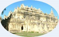
Atumashi Monastery
King Mindon (1852-1872) founded a new capital on 16 June 1858. In founding the new capital, he established seven monuments simultaneously.
They were the following:
1. The city
2. The moat
3. Mahalokamarajain pagoda
4. The ordination hall
5. The monastery
6. Pitaka taik or Royal library
7. Sudhamma Zayat or Rest-house
On 27 April 1859 king Mindon issued and order to build seven monuments simultaneously. On 15 May 1859, the pits were dug for the seven monuments to lay foundation simultaneously. On 23 May 1859, the foundation stones were laid at the seven monuments simultaneously.
Of seven monuments, one was the Mahaatulaweyan monastery. monastery. The name of monastic establishment was Mahaatulavijiyarama Taik. The Mahaatulaweyan means the incomparable monastery like Sakra's Abode (Wejayanta). The name Mahaatulavijiyarama means an incomparable monastic establishment where gained a great victory over enemies. King Mindon entrusted the Atumashi monastery and the monastic establishment to Pakhan Sayadaw U Nandasarasirisadhammadhaja Mahadammarajaguru to keep monastery under his custody on 26 April 1877. The king visited to monastery in state and dedicated it as Sanghika kyon: by making a libation on 30 May 1877. After the monastery had been adorned with carved figurines and floral designs, king Mindon visited to the monastery by waterway in state on 29 November 1877.
The king had left to the temporary abode at the top of the moat and had looked at the occasion before Pitaka texts were carried from Mahavisutarama to Atumashi monastery on 10 May 1878. The Pitaka texts were carried from Mahavisutarama Taik to Atumashi in May 1878. The Atumashi monastery was completed in 1878. It was found in a record that a Buddhist Synod was convened from 19 May 1878 to 6 June 1878 and from 7 June 1878 to 6 August 1878. A big diamond on the forehead of the Buddha Image was stolen on 29 November 1885. Atumashi monastery was burnt down in 1892. Atumashi monastery was used as a Christian Church in the early Colonial period.
The notification for preservation of the fourteen buildings was issued by the English Government according to the 904 Act No. 7, Article 3(1) on 12 December and ratified. The Atumashi monastery was included in them. The English Government preserved Atumashi on 10 August 1908.
In 1995, Atumashi monastery was reconstructed when it had burnt down after 103 years. Atumashi monastery was reconstructed at a cost of 1467.88 kyats lakhs. The ceremony for opening the Atumashi monastery was celebrated on 18 September 1996. The reconstruction of Atumashi monastery was conpleted on 30 November 1996. Atumashi monastery was transfferred to Archaeology Department on 9 January 1997.
Top
Intersting places to travel around in Mandalay

Amarapura
Amarapura meaning "City of Immortality" is a city in the Mandalay Division of Myanmar, situated 11 km to the south of Mandalay. The locals sometimes refer to it as Taungmyo (Southern City) to distinguish it from Mandalay ( Northern City).
U Bein bridge is just across the Taungthaman Lake.
King Bodawpaya (1781-1819) of the Konbaung Dynasty founded Amarapura to be his new capital in 1783, soon after he ascended the throne. In 1795, he received the first British embassy to visit Burma. Bodawpaya’s son, King Bagyidaw (1819-1837), moved the Court back to Inwa in 1823.
From 1841-1857, King Mindon Min (1853-1878) decided to make Amarapura the capital again, before relocating to his planned city of Mandalay in 1860. Today, little remains of the old city, as the palace buildings were dismantled and move by elephant to the new location, and the city walls were pulled down for use as building materials for roads and railways.
The city is known today for silk and cotton weaving, and bronze casting. It is a popular tourist day-trip from Mandalay.
Here are some of the popular places to visit in Amarapura.
- Pahtodawgyi – A paya built by King Bodawpaya in 1820 outside the city walls
- Bagaya Kyaung – wooden monastery founded by King Mindon
- U Bein’s Bridge – a 1.2 km wooden footbridge (longest teak bridge in the world)
- Kyautawgyi Paya – A temple constructed by King Pagan in 1847
- Palace Ruins – containing tombs of King Bodawpaya and King Bagyidaw. In 1800, Buddhist clergy from Sri Lanka obtained higher ordination in this city and founded the Amarapura Nikaya.

Innwa
Innwa was also known as Ava in the ancient times. It is a city in the Mandalay Division of Myanmar, situated just to the south of Amarapura on the Ayeyarwady River. It is also called Ratnapura meaning "City of Gems".
Innwa was the capital of Myanamr from 1364-1841. Prior to this, Sagaing had been the capital, but after Sagaing fell to the Shan, the court moved across the river to Innwa. The kings of Innwa set about restoring Burmese supremacy, which had disintegrated after the fall of Bagan.
In 1555, Innwa fell to the southern Burmese Kingdom of Taungoo, but in 1636, the king of Taungoo relocated his own capital to Innwa. In 1752, the Mon revolted against Burmese rule and sacked Innwa. A couple of years later, the founder of the new Konbaung Dynasty, Alaungpaya, crushed the Mon revolt, and after a period with Shwebo as his capital, re-established the court in Innwa.
 After the British conquered Lower Myanmar, after the Second Anglo-Burmese War, Upper Myanmar was commonly called the Kingdom of Innwa. During the reign of King Bodawpaya (1781-1819), the capital was moved to nearby Amarapura. However, his successor, King Bagyidaw (1819-1837), moved the Court back to Innwa in 1823. When a tremendous earthquake caused extensive damage in 1841, Innwa was finally abandoned for Amarapura. Little remains of the ancient capital today.
Some popular places to visit :
- Maha Aungmye Bonzan – A Buddhist monastery built by the wife King Bodawpaya in 1818
- Nanmyin Watch Tower– a 27 meter masonry tower, all that is left of the Innwa Palace
- Innwa Bridge– a 16 span cantilever bridge built by the British in 1934, and the only structure to cross the Ayeyarwady River.
 Sagaing
 Sagaing is the capital of Sagaing Division in Myanmar. It is located on the Ayeyarwady River, 20 km to the southwest of Mandalay on the opposite bank of the river.
Sagaing is a religious and monastic center, with numerous Buddhist monasteries. It briefly regained is position as a royal capital of Burma from 1760-1764.
The British-built a 16 span Innwa Bridge connects Sagaing with Mandalay, crossing the mighty Ayeyarwaddy River. It was built in 1934.
Popular places around
- Thabyedan Fort - This is the last ditch defence by the Myanmar, before the third invasion of the British. It lies just left to the Innwa Bridge.
- Kaungmudaw Pagoda - It is a huge whitewashed edifice is situated 10km from the town of Sagaing. The dome shaped pagoda rises up to 46 meters. At the base of the pagoda, there are 812 stone pillars, each one with a hollow and an image of a Nat in it.
- Sagaing Hill - The hill has a number of small pagodas, and now with many meditation centers. The Soon U Ponya Shin Pagoda is located on the Sagaing Hill.
Mingun
Mingun is a town in Sagaing Division, Myanmar, located 11 km up the Ayeyarwady River from Mandalay.
 The main attraction are
Mingun Pahtodawgyi - It is the ruined Mingun Paya, a Buddhist temple with the remains of a massive stupa begun by King Bodawpaya in 1790. If the constrution had been completed, it would have been the largest in the world at 150 meters. It was again damaged by 1838 earthquake.
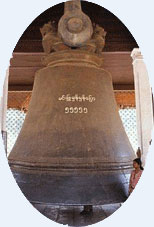
- Mingun Bell - King Bodawpaya has a gigantic bell cast to go with his huge stupa. The Mingun Bell weighs 90 tons, or 55555 viss and is today the largest uncracked, ringing bell in the world. Mingun Bell is situated right next to the Mingun Pahtodawgyi. King Bodawpaya dedicated to construct a gigantic Pagoda, a gigantic bell and a gigantic lion during his reign. But he was not able to complete the pagoda.
- Mya Theindan Pagoda - It is also known as Hninbyume Pagoda because it was donated by the Hsinbyume Princess, who was one the Queen of King Bodawpaya. It is just next to the Pahtodawgyi.

No comments:
Post a Comment